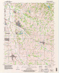
1993 Map of Farmington
USGS Topo · Published 1996About this map
Farmington and Sedalia anchor this portion of Graves County, where the landscape is defined by the Tennessee Valley Divide and an intricate network of waterways including Mayfield Creek and Little Mayfield Creek. The map reveals a rural economy shaped by both land and water, noted by the presence of a Woolen Mill and a Fish Farm. Genealogists will find significant detail in the numerous family-named burial grounds like Bean Cem, Torian Cem, and Swann Cem that dot the countryside. The northern edge shows the Corporate Mayfield boundary, signaling the reach of the county seat into the surrounding farmland. This edition synthesizes mid-century survey data with updated imagery to show the evolution of regional infrastructure, such as the Communication Tower and Mobile Home Park, amidst a landscape that remained fundamentally agricultural into the late twentieth century.
Find a feature on this map
30 named features on this map. Tap any name to fly to it.
Don’t see what you’re looking for? This feature index may not catch every label — zoom into the map to look around manually.
Map Details
Editions of this 1993 Farmington Map
This is the sole edition of this map. No revisions or reprints were ever made.
Other maps of this area

1936 · Farmington
USGS Topo · 1:24,000

1936 · Oak Level
USGS Topo · 1:24,000

1936 · Lynn Grove
USGS Topo · 1:24,000

1936 · Benton
USGS Topo · 1:48,000

1936 · Westplains
USGS Topo · 1:24,000

1936 · Kirksey
USGS Topo · 1:24,000

1951 · Kirksey
USGS Topo · 1:24,000

1951 · Farmington
USGS Topo · 1:24,000
1951 · Oak Level
USGS Topo · 1:24,000

1951 · Hickory
USGS Topo · 1:24,000