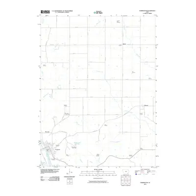
2010 Map of Farmington
USGS Topo · Published 2010About this map
Farmington anchors the southwestern corner of this survey, situated along the north bank of the Des Moines River. This early 21st-century landscape is defined by a dense network of family cemeteries and small rural clusters like Sharon and Primrose. The agricultural grid is intersected by several waterways, including Sugar Creek and Little Sugar Creek, which flow toward the river valley. The southern edge of the quadrangle shows significant public land and recreation areas, such as the Riverview Campground and portions of the Shimek Forest, including Shimek Forest Pond Two and Shimek Forest Dam Three. Genealogists will find a wealth of specific burial sites throughout the townships, from the Kennedy Farm Cemetery in the north to the Green Glade Cemetery near the river, reflecting generations of rural settlement in Van Buren County.
Find a feature on this map
61 named features on this map. Tap any name to fly to it.
Don’t see what you’re looking for? This feature index may not catch every label — zoom into the map to look around manually.
Map Details
Editions of this 2010 Farmington Map
This is the sole edition of this map. No revisions or reprints were ever made.
Other maps of this area

1958 · Burlington
USGS Topo · 1:250,000

1961 · Burlington
USGS Topo · 1:250,000

1963 · Burlington
USGS Topo · 1:250,000

1968 · Anson
USGS Topo · 1:24,000

1968 · Bonaparte
USGS Topo · 1:24,000
1968 · Argyle
USGS Topo · 1:24,000

1968 · Donnellson
USGS Topo · 1:24,000
1968 · Croton
USGS Topo · 1:24,000

1968 · Farmington
USGS Topo · 1:24,000
1981 · Salem
USGS Topo · 1:24,000