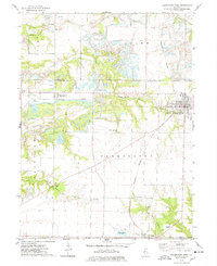
1974 Map of Farmington West
USGS Topo · Published 1978About this map
The industrial and agricultural landscapes of western Illinois converge near Farmington during the mid-1970s. This survey records a region defined by extensive Strip Mined Area developments that carved through the terrain between Middle Grove and the northern reaches of Norris. These large-scale operations stand in stark contrast to the small, enduring rural settlements and burial grounds that dot the quadrangle. Genealogists can locate several family and community landmarks, including Blakeslee Cem, Uniontown Cem, and Coal Creek Dunkard Cem. The transit infrastructure of the era is anchored by the Burlington Northern and Chicago and North Western railroads, which served the local mining and shipping interests. Waterways like Littlers Creek and South Fork Coal Creek wind through the remaining unmined fields, while specialized sites such as an Industrial Waste Pond and a Drive-in Theater reflect the social and environmental footprint of the late twentieth century.
Find a feature on this map
33 named features on this map. Tap any name to fly to it.
Don’t see what you’re looking for? This feature index may not catch every label — zoom into the map to look around manually.
Map Details
Editions of this 1974 Farmington West Map
This is the sole edition of this map. No revisions or reprints were ever made.
Other maps of this area

1912 · Canton
USGS Topo · 1:62,500

1930 · Glasford
USGS Topo · 1:62,500

1941 · Maquon
USGS Topo · 1:62,500

1943 · Maquon
USGS Topo · 1:62,500

1944 · Elmwood
USGS Topo · 1:62,500

1948 · Elmwood
USGS Topo · 1:62,500

1948 · Glasford
USGS Topo · 1:62,500

1958 · Burlington
USGS Topo · 1:250,000

1958 · Peoria
USGS Topo · 1:250,000

1961 · Burlington
USGS Topo · 1:250,000