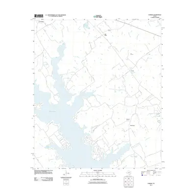
2011 Map of Farrar
USGS Topo · Published 2011About this map
Lake Limestone dominates the central and western reaches of this East Texas landscape, its intricate shoreline creating numerous inlets fed by local drainages like Coots Branch and Lies Branch. The settlement pattern is defined by rural crossroads and small communities such as Farrar and New Hope, which are interconnected by a network of Farm to Market roads and local county routes. To the north, the terrain transitions into more elevated ground where Fair Oaks and Lost Prairie are situated amidst a landscape of scattered lakes including Kennedy Lake and Sims Lake. Genealogists will find several burial grounds documented on this sheet, including Oaks Cemetery, Holt Cemetery, and New Hope Cemetery. The presence of Mine Creek in the southeast and the Texaco Svc Rd further north suggests the ongoing role of resource extraction and infrastructure in Limestone County at the time of this survey.
Find a feature on this map
61 named features on this map. Tap any name to fly to it.
Don’t see what you’re looking for? This feature index may not catch every label — zoom into the map to look around manually.
Map Details
Editions of this 2011 Farrar Map
This is the sole edition of this map. No revisions or reprints were ever made.
Other maps of this area

1919 · Fairfield
USGS Topo · 1:62,500

1920 · Mexia
USGS Topo · 1:62,500

1954 · Waco
USGS Topo · 1:250,000

1955 · Waco
USGS Topo · 1:250,000

1956 · Jewett
USGS Topo · 1:62,500

1965 · Jewett
USGS Topo · 1:24,000

1965 · Dew
USGS Topo · 1:24,000
1965 · Donie
USGS Topo · 1:24,000
1966 · Round Prairie
USGS Topo · 1:24,000
1966 · Teague South
USGS Topo · 1:24,000