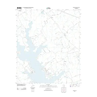
2013 Map of Farrar
USGS Topo · Published 2013About this map
Lake Limestone dominates the western half of this landscape, its irregular shoreline reaching into the central Texas countryside through numerous creek inlets and branches. Established settlements like Farrar, New Hope, and Fair Oaks anchor the surrounding rural landscape, which is marked by an extensive network of county and local roads such as FM-3371 and LCR 800. The area is geographically defined by a complex drainage system, including Sand Br, Lies Br, and Coots Br, which flow through the undulating terrain toward the main reservoir. Genealogists and local historians will find significant value in the documentation of several family and community burial sites, including Oaks Cem, Holt Cem, and New Hope Cem. The presence of Kennedy Lake and Sims Lake further north, along with named watercourses like Sanders Cr and Blains Cr, illustrates a region deeply shaped by its water resources and long-standing agricultural communities.
Find a feature on this map
100 named features on this map. Tap any name to fly to it.
Don’t see what you’re looking for? This feature index may not catch every label — zoom into the map to look around manually.
Map Details
Editions of this 2013 Farrar Map
This is the sole edition of this map. No revisions or reprints were ever made.
Other maps of this area

1919 · Fairfield
USGS Topo · 1:62,500

1920 · Mexia
USGS Topo · 1:62,500

1954 · Waco
USGS Topo · 1:250,000

1955 · Waco
USGS Topo · 1:250,000

1956 · Jewett
USGS Topo · 1:62,500

1965 · Jewett
USGS Topo · 1:24,000

1965 · Dew
USGS Topo · 1:24,000
1965 · Donie
USGS Topo · 1:24,000
1966 · Round Prairie
USGS Topo · 1:24,000
1966 · Teague South
USGS Topo · 1:24,000