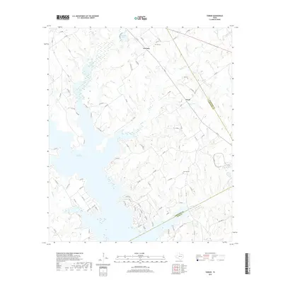
2019 Map of Farrar
USGS Topo · Published 2019About this map
Lake Limestone dominates the southern half of this landscape at the junction of Limestone, Freestone, and Leon counties. This 2019 survey captures the modern shoreline where the Navasota River is impounded, revealing the complex fingers of the reservoir as it reaches into the mouths of Coots Br and Lies Br. The rural interior is defined by a network of county roads connecting small settlements like Farrar and Fair Oaks. For those researching local family history, several burial sites are documented across the terrain, including Oaks Cem, Holt Cem, and New Hope Cem. The map illustrates the transition from the upland cattle-and-timber country down into the flooded creek bottoms, following the winding paths of Sanders Cr and Big Cr as they feed the larger lake system.
Find a feature on this map
96 named features on this map. Tap any name to fly to it.
Don’t see what you’re looking for? This feature index may not catch every label — zoom into the map to look around manually.
Map Details
Editions of this 2019 Farrar Map
This is the sole edition of this map. No revisions or reprints were ever made.
Other maps of this area

1919 · Fairfield
USGS Topo · 1:62,500

1920 · Mexia
USGS Topo · 1:62,500

1954 · Waco
USGS Topo · 1:250,000

1955 · Waco
USGS Topo · 1:250,000

1956 · Jewett
USGS Topo · 1:62,500

1965 · Jewett
USGS Topo · 1:24,000

1965 · Dew
USGS Topo · 1:24,000
1965 · Donie
USGS Topo · 1:24,000
1966 · Round Prairie
USGS Topo · 1:24,000
1966 · Teague South
USGS Topo · 1:24,000