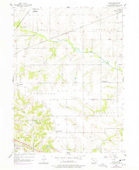
1956 Map of Farson
USGS Topo · Published 1978About this map
The Chicago Milwaukee St Paul and Pacific railroad bisects the rural landscape between Highland Center and Farson in this mid-century survey of Wapello County. The map documents a transition in rural education, marking the Highland Sch and Pleasant Grove Sch as abandoned while the Round Point Sch remains. In the southern portion of the sheet, the northern edge of Ottumwa appears near the C B & Q rail line and a prominent Substation. The terrain is defined by the winding paths of Cedar Creek and Wolf Creek, which create deep draws through the townships of Competine and Pleasant. Local history is preserved through labels for the McCormick Cem and Bladensburg Cem, alongside smaller communities like Dahlonega and Loch Burns.
Find a feature on this map
26 named features on this map. Tap any name to fly to it.
Don’t see what you’re looking for? This feature index may not catch every label — zoom into the map to look around manually.
Map Details
Editions of this 1956 Farson Map
2 editions found
Other maps of this area

1954 · Centerville
USGS Topo · 1:250,000

1954 · Des Moines
USGS Topo · 1:250,000

1956 · Des Moines
USGS Topo · 1:250,000

1956 · Farson
USGS Topo · 1:24,000

1956 · Agency
USGS Topo · 1:24,000

1956 · Ottumwa North
USGS Topo · 1:62,500

1956 · Ottumwa South
USGS Topo · 1:24,000

1956 · Ottumwa South
USGS Topo · 1:62,500

1956 · Ottumwa North
USGS Topo · 1:24,000

1957 · Des Moines
USGS Topo · 1:250,000