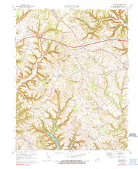
1973 Map of Faubush
USGS Topo · Published 1976About this map
Lake Cumberland defines the southwestern reach of this mid-1970s survey, where the rising waters of the reservoir meet the deeply dissected Kentucky landscape at the Pulaski Co and Russell Co line. This era captures the transition of the region as the Cumberland Parkway and Toll Road introduce modern transportation corridors through the highlands, yet the older social geography remains centered on small settlements like Faubush, Ingle, and Burnetta. Dozens of hollows, such as Graveyard and Whittle Hollow, drain into Faubush Creek and White Oak Creek, illustrating the complex drainage patterns that dictated early road placement and farm locations. For those tracing local history, the map provides precise locations for rural congregations including Cedar Point Ch and Newhope Ch, along with numerous family-oriented burial grounds like Weddle Cem and Tarter Cem.
Find a feature on this map
73 named features on this map. Tap any name to fly to it.
Don’t see what you’re looking for? This feature index may not catch every label — zoom into the map to look around manually.
Map Details
Editions of this 1973 Faubush Map
2 editions found
Other maps of this area

1911 · Monticello
USGS Topo · 1:62,500

1914 · Monticello
USGS Topo · 1:62,500

1932 · Burnside
USGS Topo · 1:62,500

1935 · Somerset
USGS Topo · 1:62,500

1953 · Phil
USGS Topo · 1:24,000

1953 · Frazer
USGS Topo · 1:24,000

1953 · Mintonville
USGS Topo · 1:24,000

1953 · Mill Springs
USGS Topo · 1:24,000

1954 · Jabez
USGS Topo · 1:24,000

1954 · Delmer
USGS Topo · 1:24,000