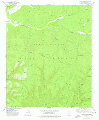
1977 Map of Faught Ridge
USGS Topo · Published 1978About this map
The Fort Apache Indian Reservation dominates this late-1970s landscape, where the rugged terrain is defined by the prominent Faught Ridge and its surrounding canyons. This area of Navajo and Gila counties reveals a network of water management features essential for ranching and survival in the high desert, including West Burn Tank, East Burn Tank, and the appropriately named Dry Lake.
Find a feature on this map
37 named features on this map. Tap any name to fly to it.
Don’t see what you’re looking for? This feature index may not catch every label — zoom into the map to look around manually.
Map Details
Editions of this 1977 Faught Ridge Map
This is the sole edition of this map. No revisions or reprints were ever made.
Other maps of this area

1886 · St Johns
USGS Topo · 1:250,000

1886 · Holbrook
USGS Topo · 1:250,000

1892 · St Johns
USGS Topo · 1:250,000

1893 · Holbrook
USGS Topo · 1:250,000

1954 · Holbrook
USGS Topo · 1:250,000

1954 · Clifton
USGS Topo · 1:250,000

1954 · Saint Johns
USGS Topo · 1:250,000

1954 · Mesa
USGS Topo · 1:250,000

1957 · Mesa
USGS Topo · 1:250,000

1957 · Holbrook
USGS Topo · 1:250,000