
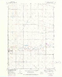
1952 Map of Faulkton East
USGS Topo · Published 1952About this map
Faulkton serves as a vital rail junction on this 1950s prairie landscape, where the Chicago Milwaukee St Paul and Pacific crosses the Chicago and North Western line. This intersection defines the local economy, supported by the Gravel Pits found south of the South Fork Snake Creek. The surrounding townships of Pulaski, Myron, Tamworth, and Lafoon are dotted with the essential infrastructure of rural South Dakota life, including the Lafoon Sch, Reed Sch, and Melius Sch. The presence of the Faulkton Landing Field and a central Water Tank highlights the town's role as a regional hub. Genealogists may find particular value in the location of the Faulkton Cem, situated at the edge of the settlement as it appeared just after the midpoint of the twentieth century.
Find a feature on this map
15 named features on this map. Tap any name to fly to it.
Don’t see what you’re looking for? This feature index may not catch every label — zoom into the map to look around manually.
Map Details
Editions of this 1952 Faulkton East Map
2 editions found
Other maps of this area

1899 · Northville
USGS Topo · 1:125,000

1899 · Redfield
USGS Topo · 1:125,000

1951 · Orient
USGS Topo · 1:24,000

1951 · Orient NW
USGS Topo · 1:24,000

1952 · Norbeck
USGS Topo · 1:24,000

1952 · Wecota
USGS Topo · 1:24,000

1952 · Faulkton West
USGS Topo · 1:24,000

1953 · Huron
USGS Topo · 1:250,000

1954 · Aberdeen
USGS Topo · 1:250,000

1954 · Huron
USGS Topo · 1:250,000