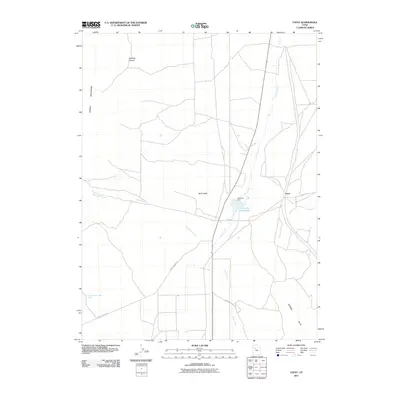
2011 Map of Faust
USGS Topo · Published 2011About this map
Rush Valley dominates this Tooele County landscape, where the historical imprint of western transit is visible along the Pony Express Rd. The small settlement of Faust serves as a central point in this arid expanse, situated near the intersection of Faust Rd and the path towards the Vernon Hills. Water management is a critical feature of the terrain, evidenced by Atherley Reservoir and its associated Atherley Dam, which capture the flows of Faust Creek. To the west, the Onaqui Mountains rise sharply, broken by the deep incision of Hellhole Canyon. This 2011 survey documents a region defined by its wide-open basins and the essential, sparse infrastructure of wells like the Lookout Pass Trail Well that supported travelers and livestock in the high desert.
Find a feature on this map
13 named features on this map. Tap any name to fly to it.
Don’t see what you’re looking for? This feature index may not catch every label — zoom into the map to look around manually.
Map Details
Editions of this 2011 Faust Map
This is the sole edition of this map. No revisions or reprints were ever made.
Other maps of this area

1885 · Tooele Valley
USGS Topo · 1:250,000

1918 · Stockton
USGS Topo · 1:62,500

1953 · Tooele
USGS Topo · 1:250,000

1955 · Deseret Peak
USGS Topo · 1:62,500

1955 · Stockton
USGS Topo · 1:62,500

1955 · Tooele
USGS Topo · 1:250,000
1971 · Vernon NE
USGS Topo · 1:24,000
1971 · Faust
USGS Topo · 1:24,000

1971 · Onaqui Mts South
USGS Topo · 1:24,000
1971 · Vernon
USGS Topo · 1:24,000