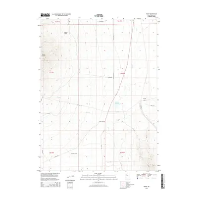
2014 Map of Faust
USGS Topo · Published 2014About this map
Faust sits at a geographic crossroads in Tooele County, where the desert landscape meets the eastern slopes of the Onaqui Mountains. This area is defined by its seasonal water systems and rural infrastructure, centered on the Atherley Reservoir and the drainage of Faust Cr. The terrain transitions from the steep relief of Hellhole Canyon to the more gradual slopes of the Vernon Hills in the southeast, reflecting the varied topography of the eastern Great Basin.
Find a feature on this map
31 named features on this map. Tap any name to fly to it.
Don’t see what you’re looking for? This feature index may not catch every label — zoom into the map to look around manually.
Map Details
Editions of this 2014 Faust Map
This is the sole edition of this map. No revisions or reprints were ever made.
Other maps of this area

1885 · Tooele Valley
USGS Topo · 1:250,000

1918 · Stockton
USGS Topo · 1:62,500

1953 · Tooele
USGS Topo · 1:250,000

1955 · Deseret Peak
USGS Topo · 1:62,500

1955 · Stockton
USGS Topo · 1:62,500

1955 · Tooele
USGS Topo · 1:250,000
1971 · Vernon NE
USGS Topo · 1:24,000
1971 · Faust
USGS Topo · 1:24,000

1971 · Onaqui Mts South
USGS Topo · 1:24,000
1971 · Vernon
USGS Topo · 1:24,000