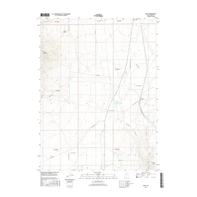
2017 Map of Faust
USGS Topo · Published 2017About this map
Onaqui Mountains foothills and the high desert plains of Rush Valley characterize this Tooele County landscape in the modern era. The area is defined by its historic transportation corridors and water management, with the Pony Express HW and Pony Express Trail RD tracing the legacy of early western mail routes. The small settlement of Faust serves as a central landmark near the intersection of various rural access roads like Rabbitbrush RD and Hills RD. Water is a critical resource in this arid environment, evidenced by the presence of the Atherley Reservoir and the drainage of Faust Cr and E Faust Cr. Significant topographical features include the steep terrain of Hellhole Canyon to the northwest and the Vernon Hills to the southeast, while modern infrastructure like Aqueduct RD and Pipeline RD underscore the ongoing human management of the Great Basin terrain.
Find a feature on this map
39 named features on this map. Tap any name to fly to it.
Don’t see what you’re looking for? This feature index may not catch every label — zoom into the map to look around manually.
Map Details
Editions of this 2017 Faust Map
This is the sole edition of this map. No revisions or reprints were ever made.
Other maps of this area

1885 · Tooele Valley
USGS Topo · 1:250,000

1918 · Stockton
USGS Topo · 1:62,500

1953 · Tooele
USGS Topo · 1:250,000

1955 · Deseret Peak
USGS Topo · 1:62,500

1955 · Stockton
USGS Topo · 1:62,500

1955 · Tooele
USGS Topo · 1:250,000
1971 · Vernon NE
USGS Topo · 1:24,000
1971 · Faust
USGS Topo · 1:24,000

1971 · Onaqui Mts South
USGS Topo · 1:24,000
1971 · Vernon
USGS Topo · 1:24,000