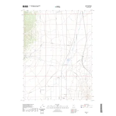
2023 Map of Faust
USGS Topo · Published 2023About this map
Rush Valley provides the setting for this study of Tooele County, where the desert landscape meets the eastern slopes of the Onaqui Mountains. The area is defined by its historic transportation corridors, most notably the Pony Express Hwy and Pony Express Trail Rd, which trace the legacy of the Old West across the basin. Small settlements like Faust and Vernon anchor the local geography, connected by a network of ranching roads and the Pacific Rail Rd. Genealogists and local historians will find the Old Faust Ranch Cem a significant landmark, situated near the winding course of Faust Creek. The presence of the Atherley Reservoir and various water-management features like Aqueduct Rd illustrate the ongoing efforts to manage resources in this arid environment between the mountains and the Vernon Hills.
Find a feature on this map
36 named features on this map. Tap any name to fly to it.
Don’t see what you’re looking for? This feature index may not catch every label — zoom into the map to look around manually.
Map Details
Editions of this 2023 Faust Map
This is the sole edition of this map. No revisions or reprints were ever made.
Other maps of this area

1885 · Tooele Valley
USGS Topo · 1:250,000

1918 · Stockton
USGS Topo · 1:62,500

1953 · Tooele
USGS Topo · 1:250,000

1955 · Deseret Peak
USGS Topo · 1:62,500

1955 · Stockton
USGS Topo · 1:62,500

1955 · Tooele
USGS Topo · 1:250,000
1971 · Vernon NE
USGS Topo · 1:24,000
1971 · Faust
USGS Topo · 1:24,000

1971 · Onaqui Mts South
USGS Topo · 1:24,000
1971 · Vernon
USGS Topo · 1:24,000