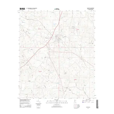
2015 Map of Fayette
USGS Topo · Published 2015About this map
The street grid of Fayette and the nearby junction at Harriston anchor this 2015 study of Jefferson County, Mississippi. This area of the Magnolia State is defined by a complex network of waterways, where Gibson Bayou and Mud Island Cr drain the northern reaches, while Stampley Cr and Morgan Fork shape the southern landscape. The map reveals a high density of rural cemeteries, such as Hicks Cem and Folkes Cem, which often mark the sites of early family homesteads and community centers in this region. Settlement patterns follow the higher ground between creek bottoms, visible in the clusters at McNair and Cadillac. Recreational and natural water bodies like Mossy Lake and American Legion Lake offer clear points of reference for those familiar with the local terrain, while the transition between t9n r1e and t8n r2e illustrates the underlying township and range survey system.
Find a feature on this map
85 named features on this map. Tap any name to fly to it.
Don’t see what you’re looking for? This feature index may not catch every label — zoom into the map to look around manually.
Map Details
Editions of this 2015 Fayette Map
This is the sole edition of this map. No revisions or reprints were ever made.
Other maps of this area

1939 · Lorman
USGS Topo · 1:62,500

1953 · Natchez
USGS Topo · 1:250,000

1956 · Natchez
USGS Topo · 1:250,000

1958 · St. Joseph
USGS Topo · 1:62,500

1959 · Natchez
USGS Topo · 1:250,000

1962 · Fayette
USGS Topo · 1:62,500

1963 · Red Lick
USGS Topo · 1:24,000

1963 · Union Church
USGS Topo · 1:62,500
1984 · Natchez
USGS Topo · 1:100,000

1984 · Brookhaven
USGS Topo · 1:100,000