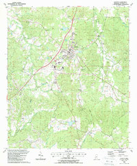
1988 Map of Fayette
USGS Topo · Published 1988About this map
The city of Fayette serves as the focal point of this Jefferson County landscape, where the intersection of local industry and rural tradition is clearly mapped. The town’s layout is documented alongside essential local institutions like the Jefferson Voc-Tech Sch and the County Sch, illustrating the community's mid-century development. Beyond the city center, the terrain is defined by the winding paths of Fairchilds Creek and Bolls Branch, which cut through a region marked by numerous family-named burial grounds and houses of worship. Genealogy researchers will find significant value in the distribution of sites like the Old Gravel Hill Cem, Darden Cem, and Locust Grove Ch, which suggest long-standing settlement patterns that predate the modern road network. The presence of Oil Wells and the American Legion Lake further highlight the varied land use of the late eighties.
Find a feature on this map
64 named features on this map. Tap any name to fly to it.
Don’t see what you’re looking for? This feature index may not catch every label — zoom into the map to look around manually.
Map Details
Editions of this 1988 Fayette Map
This is the sole edition of this map. No revisions or reprints were ever made.
Other maps of this area

1939 · Lorman
USGS Topo · 1:62,500

1953 · Natchez
USGS Topo · 1:250,000

1956 · Natchez
USGS Topo · 1:250,000

1958 · St. Joseph
USGS Topo · 1:62,500

1959 · Natchez
USGS Topo · 1:250,000

1962 · Fayette
USGS Topo · 1:62,500

1963 · Red Lick
USGS Topo · 1:24,000

1963 · Union Church
USGS Topo · 1:62,500
1984 · Natchez
USGS Topo · 1:100,000

1984 · Brookhaven
USGS Topo · 1:100,000