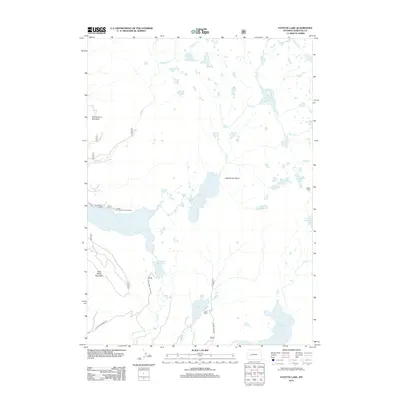
2012 Map of Fayette Lake
USGS Topo · Published 2012About this map
Fayette Lake sits at the heart of this high-elevation glacial landscape within the Wind River Range. The 2012 topography reveals a complex network of alpine hydrology, where Pole Creek and Sweeney Creek link numerous water bodies including Lower Sweeney Lake, Junction Lake, and Spruce Lake. The terrain is defined by prominent rises such as Fortification Mountain and Half Moon Mountain, while Little Brown Point offers a distinct landmark above the lake basins.
Find a feature on this map
29 named features on this map. Tap any name to fly to it.
Don’t see what you’re looking for? This feature index may not catch every label — zoom into the map to look around manually.
Map Details
Editions of this 2012 Fayette Lake Map
This is the sole edition of this map. No revisions or reprints were ever made.
Other maps of this area

1909 · Fremont Peak
USGS Topo · 1:125,000

1955 · Thermopolis
USGS Topo · 1:250,000

1955 · Lander
USGS Topo · 1:250,000

1958 · Lander
USGS Topo · 1:250,000

1958 · Thermopolis
USGS Topo · 1:250,000

1961 · Lander
USGS Topo · 1:250,000

1962 · Thermopolis
USGS Topo · 1:250,000

1964 · Boulder Lake
USGS Topo · 1:24,000
1964 · Pinedale
USGS Topo · 1:24,000

1964 · Fremont Lake South
USGS Topo · 1:24,000