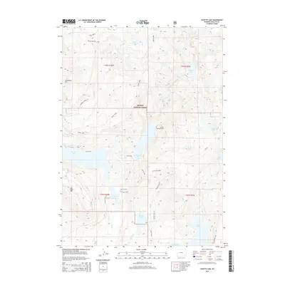
2015 Map of Fayette Lake
USGS Topo · Published 2015About this map
Bridger National Forest defines the character of this 2015 high-country survey in Sublette County, Wyoming. The terrain is a complex hydrologic network of alpine lakes and glacial runoff, with water bodies such as Fayette Lake, Half Moon Lake, and Meadow Lake concentrated in the central and southern portions. High peaks and topographic landmarks including Fortification Mtn and Half Moon Mtn provide vertical relief against the creek basins. The landscape is primarily accessible via primitive routes like the Burnt Lake Rd and specific vehicle tracks including the Meadow Lake ATV and N Sweeney Creek ATV trails. The map also records the Miller/Sweeney Cutoff, reflecting how modern forest management and recreation have layered onto this drainage system where Sweeney Creek and Pole Cr flow through the backcountry.
Find a feature on this map
34 named features on this map. Tap any name to fly to it.
Don’t see what you’re looking for? This feature index may not catch every label — zoom into the map to look around manually.
Map Details
Editions of this 2015 Fayette Lake Map
This is the sole edition of this map. No revisions or reprints were ever made.
Other maps of this area

1909 · Fremont Peak
USGS Topo · 1:125,000

1955 · Thermopolis
USGS Topo · 1:250,000

1955 · Lander
USGS Topo · 1:250,000

1958 · Lander
USGS Topo · 1:250,000

1958 · Thermopolis
USGS Topo · 1:250,000

1961 · Lander
USGS Topo · 1:250,000

1962 · Thermopolis
USGS Topo · 1:250,000

1964 · Boulder Lake
USGS Topo · 1:24,000
1964 · Pinedale
USGS Topo · 1:24,000

1964 · Fremont Lake South
USGS Topo · 1:24,000