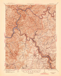
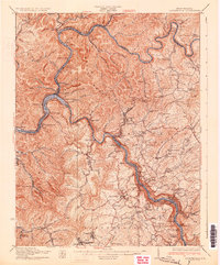
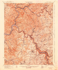
1931 Map of Fayetteville
USGS Topo · Published 1945About this map
Gauley River and Kanawha River carve through the center of this 1931 West Virginia survey, creating a dramatic corridor for early industry and transportation. The confluence at Gauley Bridge serves as a focal point, where the Chesapeake and Ohio and Central Railroad lines follow the water's edge, supporting local settlements like Glen Ferris and Ansted. Higher elevations are marked by the presence of Gauley Mountain and Cotton Hill, with numerous small schools such as Romont Sch and Fairview Sch serving the rural gaps between river towns.
Find a feature on this map
122 named features on this map. Tap any name to fly to it.
Don’t see what you’re looking for? This feature index may not catch every label — zoom into the map to look around manually.
Map Details
Editions of this 1931 Fayetteville Map
3 editions found
Other maps of this area

1887 · Hinton
USGS Topo · 1:125,000

1889 · Nicholas
USGS Topo · 1:125,000

1891 · Nicholas
USGS Topo · 1:125,000

1891 · Raleigh
USGS Topo · 1:125,000

1892 · Hinton
USGS Topo · 1:125,000

1897 · Kanawha Falls
USGS Topo · 1:125,000

1897 · Raleigh
USGS Topo · 1:125,000

1900 · Kanawha Falls
USGS Topo · 1:125,000

1901 · Nicholas
USGS Topo · 1:125,000

1901 · Kanawha Falls
USGS Topo · 1:125,000