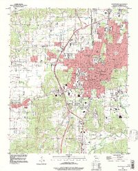
1995 Map of Fayetteville
USGS Topo · Published 1998About this map
Fayetteville dominates the central landscape of this Northwest Arkansas survey, showcasing the city's significant 1990s footprint and institutional core. The sprawling campus of the University of Arkansas serves as a major focal point, flanked by the Veterans Hospital and the historic Western Methodist Assembly grounds on Mount Sequoyah. The map reveals a transition from dense urban development to the surrounding highlands, including Washington Mountain and Kessler Mountain, which rise sharply above the southern and western valleys.
Find a feature on this map
61 named features on this map. Tap any name to fly to it.
Don’t see what you’re looking for? This feature index may not catch every label — zoom into the map to look around manually.
Map Details
Editions of this 1995 Fayetteville Map
This is the sole edition of this map. No revisions or reprints were ever made.
Other maps of this area

1898 · Winslow
USGS Topo · 1:125,000

1899 · Fayetteville
USGS Topo · 1:125,000

1901 · Winslow
USGS Topo · 1:125,000

1901 · Fayetteville
USGS Topo · 1:125,000

1904 · Fayetteville
USGS Topo · 1:125,000

1946 · Fort Smith
USGS Topo · 1:250,000

1954 · Tulsa
USGS Topo · 1:250,000

1958 · Sonora
USGS Topo · 1:24,000

1958 · Fayetteville
USGS Topo · 1:24,000

1958 · Elkins
USGS Topo · 1:24,000