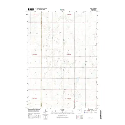
2015 Map of Fedora
USGS Topo · Published 2015About this map
Fedora sits at the intersection of a vast agricultural grid along the southern edge of this Sanborn and Miner County landscape. The terrain is defined by the wandering paths of Jim Cr and Redstone Cr, which cut through a mosaic of prairie depressions and wetlands. This 2015 survey reveals the persistence of early settlement patterns, where rural life is anchored by several small burial grounds including Prairie Flower Cem, Morgans Cem, and the Fedora Cem. The map illustrates the remarkably consistent section-line road system, such as 226th St and 418th Ave, which has dictated the movement and land use of this South Dakota region for over a century. For the local historian or genealogist, the exact placement of these cemeteries and the small settlement of Fedora provide precise coordinates for tracing family roots and farmstead locations in this quintessential Great Plains environment.
Find a feature on this map
27 named features on this map. Tap any name to fly to it.
Don’t see what you’re looking for? This feature index may not catch every label — zoom into the map to look around manually.
Map Details
Editions of this 2015 Fedora Map
This is the sole edition of this map. No revisions or reprints were ever made.
Other maps of this area

1899 · Alexandria
USGS Topo · 1:125,000

1899 · De Smet
USGS Topo · 1:125,000

1953 · Watertown
USGS Topo · 1:250,000

1955 · Sioux Falls
USGS Topo · 1:250,000

1957 · Farwell NW
USGS Topo · 1:24,000

1958 · Sioux Falls
USGS Topo · 1:250,000

1958 · Watertown
USGS Topo · 1:250,000
1971 · Artesian NW
USGS Topo · 1:24,000

1971 · Fedora
USGS Topo · 1:24,000
1971 · Artesian
USGS Topo · 1:24,000