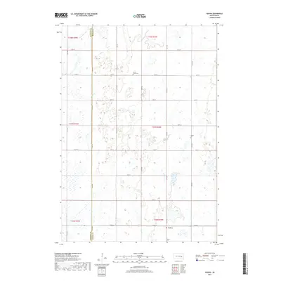
2017 Map of Fedora
USGS Topo · Published 2017About this map
Fedora sits at the intersection of a rigid section-line road network in this eastern South Dakota landscape, where the prairie is defined by a complex hydrology of intermittent wetlands and small streams. The community is anchored by the Fedora Cem to its south, while the wider agricultural region is dotted with burial grounds such as Prairie Flower Cem and Morgans Cem, which offer significant value for genealogists tracing early settlement families. Meandering waterways including Redstone Cr, W Redstone Cr, and Jim Cr carve through the landscape, creating a natural contrast to the straight paths of Co HWY 27 and Co RD 17. The distribution of these features reveals an economy deeply tied to the land and a history of small-town persistence in the American heartland.
Find a feature on this map
30 named features on this map. Tap any name to fly to it.
Don’t see what you’re looking for? This feature index may not catch every label — zoom into the map to look around manually.
Map Details
Editions of this 2017 Fedora Map
This is the sole edition of this map. No revisions or reprints were ever made.
Other maps of this area

1899 · Alexandria
USGS Topo · 1:125,000

1899 · De Smet
USGS Topo · 1:125,000

1953 · Watertown
USGS Topo · 1:250,000

1955 · Sioux Falls
USGS Topo · 1:250,000

1957 · Farwell NW
USGS Topo · 1:24,000

1958 · Sioux Falls
USGS Topo · 1:250,000

1958 · Watertown
USGS Topo · 1:250,000
1971 · Artesian NW
USGS Topo · 1:24,000

1971 · Fedora
USGS Topo · 1:24,000
1971 · Artesian
USGS Topo · 1:24,000