
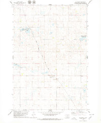
1978 Map of Feinstein Lake
USGS Topo · Published 1979About this map
The rolling prairie of the McPherson and Campbell county border is defined by a complex network of glacial depressions and wetlands. Feinstein Lake and Heupel Lake are central features in a landscape dominated by conservation and land management, including the National Waterfowl Production Area and the North Jackson State Public Shooting Area. These designations reflect the region's importance to the Central Flyway and the prairie pothole ecosystem.
Find a feature on this map
9 named features on this map. Tap any name to fly to it.
Don’t see what you’re looking for? This feature index may not catch every label — zoom into the map to look around manually.
Map Details
Editions of this 1978 Feinstein Lake Map
This is the sole edition of this map. No revisions or reprints were ever made.
Other maps of this area

1954 · Aberdeen
USGS Topo · 1:250,000

1956 · Aberdeen
USGS Topo · 1:250,000

1978 · Hillsview SE
USGS Topo · 1:24,000

1978 · Bowdle-Hosmer Lake
USGS Topo · 1:24,000

1978 · Java SE
USGS Topo · 1:24,000

1978 · Eureka West
USGS Topo · 1:24,000

1978 · Flat Lake
USGS Topo · 1:24,000

1978 · Eureka East
USGS Topo · 1:24,000

1978 · Mutske Lake
USGS Topo · 1:24,000
1978 · Hillsview
USGS Topo · 1:24,000