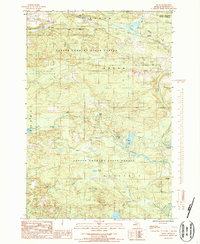
1986 Map of Felch
USGS Topo · Published 1986About this map
The Copper Country State Forest dominates this section of the Upper Peninsula, where the timber and mining industries have shaped the landscape. Centered around the settlement of Felch, the map reveals a network of industrial legacy markers, including a Rock Quarry and a prominent Lookout Tower positioned for fire overwatch. An Old Railroad Grade traces the historic transport routes that once hauled heavy minerals and timber through the townships of Felch, Breen, and Waucedah. The hydrology is defined by the Sturgeon River and its numerous tributaries like Finn Town Creek, which pass through a terrain dotted with small glacial lakes such as Necktie Lake and Brown Lake. This 1980s-era survey documents the transition from active industrial extraction to managed forest land, preserving the locations of smaller locales like Spruce and the uniquely named Finn Town.
Find a feature on this map
31 named features on this map. Tap any name to fly to it.
Don’t see what you’re looking for? This feature index may not catch every label — zoom into the map to look around manually.
Map Details
Editions of this 1986 Felch Map
This is the sole edition of this map. No revisions or reprints were ever made.
Other maps of this area

1954 · Escanaba
USGS Topo · 1:250,000

1955 · Norway
USGS Topo · 1:24,000

1955 · Vulcan
USGS Topo · 1:24,000

1955 · Norway
USGS Topo · 1:62,500

1955 · Ralph
USGS Topo · 1:62,500

1956 · Foster City
USGS Topo · 1:62,500

1957 · Escanaba
USGS Topo · 1:250,000

1957 · Northland
USGS Topo · 1:62,500

1958 · Escanaba
USGS Topo · 1:250,000

1958 · Marquette
USGS Topo · 1:250,000