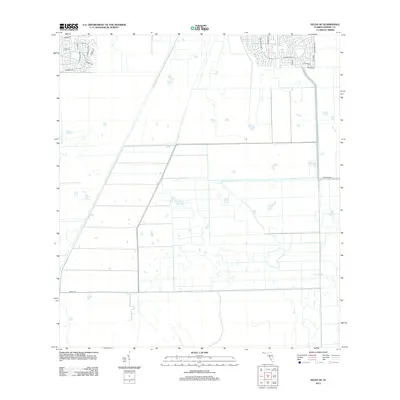
2012 Map of Felda NE
USGS Topo · Published 2012About this map
Collins Slough anchors the southeastern landscape of this inland Florida territory, where the terrain is defined by a dense network of drainage channels and agricultural divisions. While the central and western portions of the quadrangle remain largely open with geometric field patterns, suburban expansion is evident in the northern corners. In the northeast, residential development is marked by a grid of streets including Lexington Blvd and Se Banyon Blvd. To the northwest, circular street designs like Lamkin Cir and Bamboo Cir indicate planned communities pushing into the rural expanse. Transport corridors such as Yeehaw Ave and Sears Rd provide the primary east-west access through this developing section of the Florida interior during the early twenty-first century.
Find a feature on this map
20 named features on this map. Tap any name to fly to it.
Don’t see what you’re looking for? This feature index may not catch every label — zoom into the map to look around manually.
Map Details
Editions of this 2012 Felda NE Map
This is the sole edition of this map. No revisions or reprints were ever made.
Other maps of this area

1956 · West Palm Beach
USGS Topo · 1:250,000

1957 · West Palm Beach
USGS Topo · 1:250,000

1958 · West Palm Beach
USGS Topo · 1:250,000

1958 · Felda SE
USGS Topo · 1:24,000

1958 · Goodno
USGS Topo · 1:24,000

1958 · Felda
USGS Topo · 1:24,000

1958 · Felda NE
USGS Topo · 1:24,000

1958 · Sears
USGS Topo · 1:24,000
1958 · La Belle
USGS Topo · 1:24,000

1970 · La Belle 4 NW
USGS Topo · 1:24,000