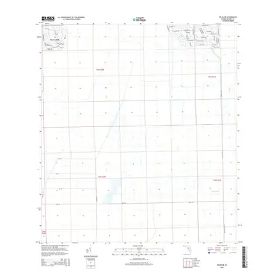
2015 Map of Felda NE
USGS Topo · Published 2015About this map
Port Labelle serves as the primary residential hub in this corner of Florida, defined by a distinct network of winding suburban drives and parkways. The layout of streets such as Hyacinth Pky, Silverfish Dr, and Bethlehem Ave contrasts sharply with the vast, open grid of the surrounding agricultural landscape. This 2015 survey reveals how modern drainage and land management have reshaped the terrain, most notably through the water systems connected to Collins Slough. Further south, the map transitions into a more traditional rural pattern, where straight access ways like Sears Rd, Goodno Rd, and Gerber Rd facilitate transit through the large, rectangular land sections of the Florida interior. These roads and the persistent presence of the slough illustrate the ongoing balance between residential expansion and the drainage requirements of the low-lying Hendry County landscape.
Find a feature on this map
49 named features on this map. Tap any name to fly to it.
Don’t see what you’re looking for? This feature index may not catch every label — zoom into the map to look around manually.
Map Details
Editions of this 2015 Felda NE Map
This is the sole edition of this map. No revisions or reprints were ever made.
Other maps of this area

1956 · West Palm Beach
USGS Topo · 1:250,000

1957 · West Palm Beach
USGS Topo · 1:250,000

1958 · West Palm Beach
USGS Topo · 1:250,000

1958 · Felda SE
USGS Topo · 1:24,000

1958 · Goodno
USGS Topo · 1:24,000

1958 · Felda
USGS Topo · 1:24,000

1958 · Felda NE
USGS Topo · 1:24,000

1958 · Sears
USGS Topo · 1:24,000
1958 · La Belle
USGS Topo · 1:24,000

1970 · La Belle 4 NW
USGS Topo · 1:24,000