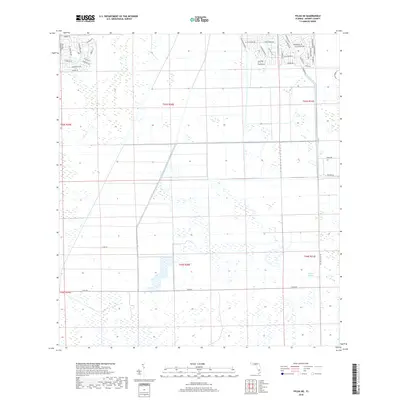
2018 Map of Felda NE
USGS Topo · Published 2018About this map
Collins Slough defines the hydrologic character of this interior Florida landscape, where the flat terrain of Hendry County is dominated by seasonal wetlands and a grid of rural development. The northern sections of the map show the encroaching suburban layout of Port La Belle, with residential clusters organized along streets like Lamkin Cir, W Carnation Dr, and Se Raintree Blvd. These neighborhoods contrast sharply with the vast, open tracts of the southern half of the quadrangle, where the Public Land Survey System grid is visible through boundaries such as t44s r30e. Infrastructure in this area is primarily focused on drainage and access for agriculture or future residential expansion, evidenced by the long, straight stretches of Helms Rd and Wellington Pkwy that cut through the low-lying wetlands.
Find a feature on this map
48 named features on this map. Tap any name to fly to it.
Don’t see what you’re looking for? This feature index may not catch every label — zoom into the map to look around manually.
Map Details
Editions of this 2018 Felda NE Map
This is the sole edition of this map. No revisions or reprints were ever made.
Other maps of this area

1956 · West Palm Beach
USGS Topo · 1:250,000

1957 · West Palm Beach
USGS Topo · 1:250,000

1958 · West Palm Beach
USGS Topo · 1:250,000

1958 · Felda SE
USGS Topo · 1:24,000

1958 · Goodno
USGS Topo · 1:24,000

1958 · Felda
USGS Topo · 1:24,000

1958 · Felda NE
USGS Topo · 1:24,000

1958 · Sears
USGS Topo · 1:24,000
1958 · La Belle
USGS Topo · 1:24,000

1970 · La Belle 4 NW
USGS Topo · 1:24,000