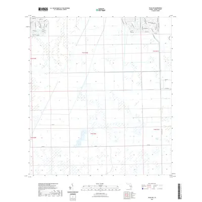
2021 Map of Felda NE
USGS Topo · Published 2021About this map
Collins Slough dominates the southeastern interior of this Hendry County landscape, where the natural drainage patterns of south-central Florida intersect with a maturing suburban grid. The northern portion of the quadrangle shows the residential expansion of Port La Belle, characterized by a series of planned, circular street layouts such as Lamkin Cir and Green Cir. These suburban pockets, including neighborhoods around Se Raintree Blvd and Hyacinth Pkwy, contrast sharply with the expansive agricultural and wetland tracts to the south. The road network transition from suburban avenues like W Glendale Ave to rural connectors like Sears Rd reflects the edge of development in 2021. This area serves as a critical point of study for understanding how modern water management and residential planning are carved into the traditional sloughs and wetlands of the Florida interior.
Find a feature on this map
50 named features on this map. Tap any name to fly to it.
Don’t see what you’re looking for? This feature index may not catch every label — zoom into the map to look around manually.
Map Details
Editions of this 2021 Felda NE Map
This is the sole edition of this map. No revisions or reprints were ever made.
Other maps of this area

1956 · West Palm Beach
USGS Topo · 1:250,000

1957 · West Palm Beach
USGS Topo · 1:250,000

1958 · West Palm Beach
USGS Topo · 1:250,000

1958 · Felda SE
USGS Topo · 1:24,000

1958 · Goodno
USGS Topo · 1:24,000

1958 · Felda
USGS Topo · 1:24,000

1958 · Felda NE
USGS Topo · 1:24,000

1958 · Sears
USGS Topo · 1:24,000
1958 · La Belle
USGS Topo · 1:24,000

1970 · La Belle 4 NW
USGS Topo · 1:24,000