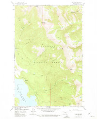
1958 Map of Felix Peak
USGS Topo · Published 1975About this map
The Hungry Horse Reservoir South Fork Flathead River dominates the southwestern corner of this survey, reflecting the mid-century transformation of the landscape within the Flathead National Forest. This interior wilderness, mapped in the late 1950s, reveals a network of fire management and resource extraction, notably the Felix Mine tucked below the high ridges. Topographical high points such as Felix Peak and Mount Baptiste are connected by a series of primitive routes including the Felix Basin Trail and the Baptiste Lookout Trail. Administrative presence in this remote terrain is anchored by the Betty Creek Ranger Station and several observation points like Baptiste Lookout and Canyon Lookout. The drainage patterns of Unawah Creek, Dirtyface Creek, and Logan Creek define the steep basins that characterize this section of the Rocky Mountains, illustrating the challenging geography navigated by early foresters and miners.
Find a feature on this map
36 named features on this map. Tap any name to fly to it.
Don’t see what you’re looking for? This feature index may not catch every label — zoom into the map to look around manually.
Map Details
Editions of this 1958 Felix Peak Map
Other maps of this area

1914 · Nyack
USGS Topo · 1:125,000

1958 · Circus Peak
USGS Topo · 1:24,000

1958 · Nimrod
USGS Topo · 1:24,000

1958 · Quintonkon
USGS Topo · 1:24,000

1958 · Felix Peak
USGS Topo · 1:24,000

1960 · Cut Bank
USGS Topo · 1:250,000

1963 · Cut Bank
USGS Topo · 1:250,000

1964 · Cut Bank
USGS Topo · 1:250,000

1964 · Essex
USGS Topo · 1:24,000

1964 · Pinnacle
USGS Topo · 1:24,000