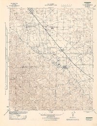
1944 Map of Fellows
USGS Topo · Published 1944About this map
The Naval Petroleum Reserve No 2 defines the landscape of this 1944 War Department survey, where the industrial infrastructure of the California oil patch meets the steep slopes of the Temblor Range. Centered on the town of Fellows, the map illustrates a region dominated by energy extraction during the height of the war effort. Extensive networks of unimproved roads and pipelines connect major facilities like the Chanslor-Canfield Midway Oil Co and the General Petroleum Corp Midway Pumping Sta. The settlement of Derby Acres sits along the primary thoroughfare, while the Associate Oil Co Camp provides a record of the worker housing that supported these remote operations. To the west, the terrain rises sharply toward Midway Peak and the Panorama Hills, marking the rugged transition from the San Joaquin Valley floor to the high ridges of the Kern and San Luis Obispo county line.
Find a feature on this map
20 named features on this map. Tap any name to fly to it.
Don’t see what you’re looking for? This feature index may not catch every label — zoom into the map to look around manually.
Map Details
Editions of this 1944 Fellows Map
This is the sole edition of this map. No revisions or reprints were ever made.
Other maps of this area

1910 · Buena Vista Lake
USGS Topo · 1:125,000

1912 · McKittrick
USGS Topo · 1:125,000

1912 · Buena Vista Lake
USGS Topo · 1:125,000

1932 · West Elk Hills
USGS Topo · 1:31,680

1932 · East Elk Hills
USGS Topo · 1:31,680
1942 · Buttonwillow
USGS Topo · 1:62,500

1943 · Maricopa
USGS Topo · 1:31,680

1944 · Panorama Hills
USGS Topo · 1:31,680
1944 · Elkhorn Hills
USGS Topo · 1:31,680
1944 · Midway Peak SW
USGS Topo · 1:31,680