1953 Map of Fellsmere NW
USGS Topo · Published 1971About this map
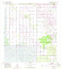
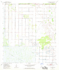
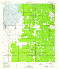
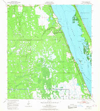
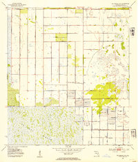
The vast wetlands of St Johns Marsh dominate the southern landscape of this mid-century Brevard County survey. The map documents a period of significant hydrological modification in East Florida, characterized by an extensive network of Levees and Spoil Banks designed to manage the water flow of the St. Johns River basin. While the northern portion shows the early residential platting of Palm Bay, much of the terrain remains defined by high water tables and agricultural engineering. Numerous Flowing Wells are recorded throughout the grid, particularly in the southeastern quadrant, highlighting the region's reliance on artesian water sources during this era of development. The contrast between the rigid, rectangular drainage canals and the organic, sprawling marshland illustrates the mid-20th-century effort to reclaim and subdivide this part of Florida.
Find a feature on this map
7 named features on this map. Tap any name to fly to it.
Don’t see what you’re looking for? This feature index may not catch every label — zoom into the map to look around manually.
Map Details
Editions of this 1953 Fellsmere NW Map
3 editions found
Other maps of this area
1949 · Melbourne West
USGS Topo · 1:24,000

1949 · Fellsmere
USGS Topo · 1:24,000
1949 · Melbourne East
USGS Topo · 1:24,000
1949 · Grant
USGS Topo · 1:24,000

1951 · Melbourne East
USGS Topo · 1:24,000
1951 · Fellsmere
USGS Topo · 1:24,000
1951 · Melbourne West
USGS Topo · 1:24,000

1951 · Grant
USGS Topo · 1:24,000
1953 · Fellsmere SW
USGS Topo · 1:24,000
1953 · Fellsmere NW
USGS Topo · 1:24,000