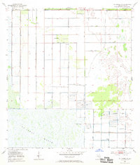
1953 Map of Fellsmere NW
USGS Topo · Published 1969About this map
The St Johns Marsh dominates the southern landscape of this 1950s survey, revealing an intricate system of water management in the Florida wetlands. Constructed infrastructure, including numerous instances of a Spoil Bank and a continuous Levee system, crisscrosses the terrain, marking the intersection of natural hydrology and human engineering. These features delineate the geometric boundaries of land reclamation and water control efforts common to this region's development era. Scattered throughout the quadrangle, several labels for a Flowing Well indicate the importance of artesian water sources for local drainage or irrigation. This map provides a detailed look at the rural landscape before more intensive late-century development, focusing primarily on the drainage patterns and the engineered barriers that shaped the early 20th-century Florida interior.
Find a feature on this map
4 named features on this map. Tap any name to fly to it.
Don’t see what you’re looking for? This feature index may not catch every label — zoom into the map to look around manually.
Map Details
Editions of this 1953 Fellsmere NW Map
3 editions found

Other maps of this area

1949 · Melbourne West
USGS Topo · 1:24,000

1949 · Fellsmere
USGS Topo · 1:24,000

1949 · Melbourne East
USGS Topo · 1:24,000

1949 · Grant
USGS Topo · 1:24,000

1951 · Melbourne East
USGS Topo · 1:24,000

1951 · Fellsmere
USGS Topo · 1:24,000

1951 · Melbourne West
USGS Topo · 1:24,000

1951 · Grant
USGS Topo · 1:24,000

1953 · Fellsmere SW
USGS Topo · 1:24,000

1953 · Fellsmere NW
USGS Topo · 1:24,000