
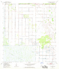
1953 Map of Fellsmere NW
USGS Topo · Published 1954About this map
St Johns Marsh dominates the southern landscape of this 1950s Brevard County quadrangle, showing a complex network of reclaimed wetlands and engineering. The map reveals an intensive effort to manage the water table through a geometric grid of structures labeled Levee and Spoil Bank, which partition the low-lying terrain into functional tracts. Several scattered water sources, designated as Flowing Wells and Flowing Well, suggest the importance of groundwater access for agriculture or cattle operations in this section of the Florida wilderness during the mid-century. The transition from natural marshland to an engineered environment is starkly visible in the northern half of the sheet, where survey lines and man-made embankments overwrite the once-undifferentiated wetlands.
Find a feature on this map
7 named features on this map. Tap any name to fly to it.
Don’t see what you’re looking for? This feature index may not catch every label — zoom into the map to look around manually.
Map Details
Editions of this 1953 Fellsmere NW Map
3 editions found

Other maps of this area

1949 · Melbourne West
USGS Topo · 1:24,000

1949 · Fellsmere
USGS Topo · 1:24,000

1949 · Melbourne East
USGS Topo · 1:24,000

1949 · Grant
USGS Topo · 1:24,000

1951 · Melbourne East
USGS Topo · 1:24,000

1951 · Fellsmere
USGS Topo · 1:24,000

1951 · Melbourne West
USGS Topo · 1:24,000

1951 · Grant
USGS Topo · 1:24,000

1953 · Fellsmere SW
USGS Topo · 1:24,000

1953 · Deer Park SE
USGS Topo · 1:24,000