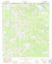
1984 Map of Felps
USGS Topo · Published 1985About this map
Louisiana and Mississippi meet along the northern boundary of this 1980s landscape, where the rural terrain of East Feliciana Parish transitions into Amite County. This area is characterized by a dense network of watercourses, including the central Sandy Creek and its many tributaries like Pretty Creek and Walnut Branch. Small, dispersed settlements such as Woodland and Teddy are connected by a web of unimproved roads and light-duty trails, reflecting a late 20th-century rural economy. Near the Mississippi border, the Freeman Landing Strip highlights the reliance on private aviation in this sparsely populated region. Further east, the community of Felixville sits near the confluence of Clear Creek and a local drainage branch, while Felps serves as a northern waypoint. The map's fine contour lines illustrate the subtle elevation changes that define the drainage basins of the Florida Parishes.
Find a feature on this map
16 named features on this map. Tap any name to fly to it.
Don’t see what you’re looking for? This feature index may not catch every label — zoom into the map to look around manually.
Map Details
Editions of this 1984 Felps Map
2 editions found
Other maps of this area

1906 · Bayou Sara
USGS Topo · 1:125,000

1941 · Woodland
USGS Topo · 1:31,680

1941 · Norwood
USGS Topo · 1:31,680

1941 · Gilead
USGS Topo · 1:31,680

1941 · Chipola
USGS Topo · 1:31,680

1942 · Gilead
USGS Topo · 1:31,680

1945 · Norwood
USGS Topo · 1:31,680

1945 · Chipola
USGS Topo · 1:31,680

1946 · Clinton
USGS Topo · 1:31,680

1949 · Bluff Creek
USGS Topo · 1:31,680