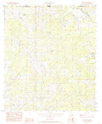
1984 Map of Woodland
USGS Topo · Published 1985About this map
Woodland sits at the center of this rural landscape, which is defined by a dense network of creek branches and small settlements straddling the border of Amite Co and East Feliciana Parish. This provisional study reveals a pattern of dispersed homesteads and small community centers like Felixville, Teddy, and Felps connected by improved and unimproved roads. The terrain is deeply carved by drainage systems, most notably Sandy Creek and Woodland Creek, which flow through the timbered hills of the Louisiana and Mississippi state line area.
Find a feature on this map
18 named features on this map. Tap any name to fly to it.
Don’t see what you’re looking for? This feature index may not catch every label — zoom into the map to look around manually.
Map Details
Editions of this 1984 Woodland Map
2 editions found
Other maps of this area

1906 · Bayou Sara
USGS Topo · 1:125,000

1941 · Woodland
USGS Topo · 1:31,680

1941 · Norwood
USGS Topo · 1:31,680

1941 · Gilead
USGS Topo · 1:31,680

1941 · Chipola
USGS Topo · 1:31,680

1942 · Gilead
USGS Topo · 1:31,680

1945 · Norwood
USGS Topo · 1:31,680

1945 · Chipola
USGS Topo · 1:31,680

1946 · Clinton
USGS Topo · 1:31,680

1949 · Bluff Creek
USGS Topo · 1:31,680