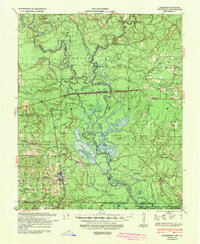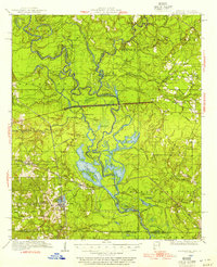
1934 Map of Felsenthal
USGS Topo · Published 1954About this map
The Ouachita River and Saline River converge in this low-lying river bottom landscape during the early 1930s, creating a complex network of bayous, sloughs, and ridges along the Arkansas-Louisiana border. The settlement of Huttig and the nearby town of Felsenthal serve as the primary hubs of human activity, supported by the Missouri Pacific railroad line. The map reveals an economy tied to the land and water, with several logging tracks penetrating the dense woods and numerous family or community landmarks such as St Marys Ch and Smith Chapel. Significant topographical features like Grand Marais and Marais Saline dominate the central basin, while localized history is preserved in labels for the Macedonian Cem 35 and an ancient Indian Mound near Coffee Prairie. This survey captures the region just as aerial photography began to supplement traditional ground topography, providing a precise record of the winding watercourses and timber-rich ridges.
Find a feature on this map
76 named features on this map. Tap any name to fly to it.
Don’t see what you’re looking for? This feature index may not catch every label — zoom into the map to look around manually.
Map Details
Editions of this 1934 Felsenthal Map
2 editions found

Historical Maps of Huttig Through Time
4 maps found