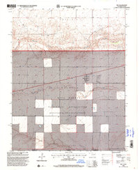
1998 Map of Felt
USGS Topo · Published 2001About this map
Felt stands as a focal point of human settlement in this High Plains region, where the high-altitude shortgrass prairie meets the water systems of the Oklahoma Panhandle. The landscape is defined by the Beaver River and its tributaries, including Seneca Creek and Aqua Fria Creek, which carve distinct paths through the terrain of Wheeless and Gresham. Large portions of the territory are preserved within the Rita Blanca National Grassland, highlighting the regional commitment to conservation and managed land use. The map reveals a high density of water infrastructure through numerous labeled wells, essential for life in this arid climate, alongside localized industry such as a Gravel Pit. The state line between Oklahoma and Texas runs through the lower portion of the sheet, marking the intersection of Cimarron and Dallam counties.
Find a feature on this map
12 named features on this map. Tap any name to fly to it.
Don’t see what you’re looking for? This feature index may not catch every label — zoom into the map to look around manually.
Map Details
Editions of this 1998 Felt Map
This is the sole edition of this map. No revisions or reprints were ever made.
Other maps of this area

1954 · Dalhart
USGS Topo · 1:250,000

1958 · Dalhart
USGS Topo · 1:250,000

1962 · Dalhart
USGS Topo · 1:250,000

1969 · Felt SW
USGS Topo · 1:24,000

1969 · Boise City NW
USGS Topo · 1:24,000

1969 · Boise City SW
USGS Topo · 1:24,000

1969 · Wheeless
USGS Topo · 1:24,000

1969 · Felt
USGS Topo · 1:24,000

1969 · Felt NE
USGS Topo · 1:24,000

1973 · Buffalo Springs
USGS Topo · 1:24,000