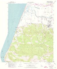
1959 Map of Ferndale
USGS Topo · Published 1974About this map
Ferndale sits at the foot of Wildcat Ridge in this survey of coastal Humboldt County, where the dairy-rich Eel River valley meets the Pacific shore. The mapping details the transitional landscape from the Sand Dunes at Centerville Beach to the steep, creek-cut hills of the interior. A distinct maritime history is visible along the coast, marked by the Wreck of Northerner Historical Marker and the Naval Oceanography Station. Further inland, the map captures the rural infrastructure of the mid-20th century, including the Island School and the Fairgrounds. The settlement pattern follows the waterways and ridges, with family-named holdings like Fern Cottage, Occidental Ranch, and Bunker Hill Ranch anchoring the landscape. Waterways such as the Salt River and Russ Creek define the drainage of the coastal hills into the tidal sloughs.
Find a feature on this map
54 named features on this map. Tap any name to fly to it.
Don’t see what you’re looking for? This feature index may not catch every label — zoom into the map to look around manually.
Map Details
Editions of this 1959 Ferndale Map
3 editions found
Other maps of this area

1916 · Cape Fortunas
USGS Topo · 1:62,500

1919 · Glynn
USGS Topo · 1:62,500

1921 · Cape Mendocino
USGS Topo · 1:62,500

1943 · Ferndale
USGS Topo · 1:62,500

1944 · Fortuna
USGS Topo · 1:62,500

1949 · Eureka
USGS Topo · 1:250,000

1950 · Cape Mendocino
USGS Topo · 1:62,500

1950 · Scotia
USGS Topo · 1:62,500

1951 · Scotia
USGS Topo · 1:62,500

1951 · Cape Mendocino
USGS Topo · 1:62,500