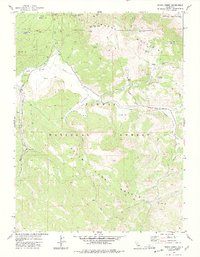
1977 Map of Ferris Creek
USGS Topo · Published 1978About this map
The Diamond Mountains dominate this high-altitude landscape along the border of Lassen and Plumas counties. Much of the southern terrain is protected as part of the Plumas State Game Refuge within the Plumas National Forest, a region defined by complex drainages like Ferris Creek and Last Chance Creek. This area served as a workspace for early timber and mineral extraction, evidenced by the presence of Johnson Mill and a cluster of remote mining operations including the Grey Goose Mine and Eagle Rock Mine near East Canyon.
Find a feature on this map
38 named features on this map. Tap any name to fly to it.
Don’t see what you’re looking for? This feature index may not catch every label — zoom into the map to look around manually.
Map Details
Editions of this 1977 Ferris Creek Map
This is the sole edition of this map. No revisions or reprints were ever made.
Other maps of this area

1886 · Honey Lake
USGS Topo · 1:250,000

1890 · Sierraville
USGS Topo · 1:125,000

1891 · Honey Lake
USGS Topo · 1:250,000

1892 · Sierraville
USGS Topo · 1:125,000

1893 · Honey Lake
USGS Topo · 1:250,000

1894 · Sierraville
USGS Topo · 1:125,000

1950 · Chilcoot
USGS Topo · 1:62,500

1950 · Portola
USGS Topo · 1:62,500

1950 · Milford
USGS Topo · 1:62,500

1954 · Doyle
USGS Topo · 1:62,500