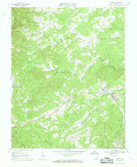
1967 Map of Ferrum
USGS Topo · Published 1969About this map
The Ferrum community and its namesake Ferrum Jr College anchor the eastern landscape of this Piedmont-foothills survey. The Norfolk and Western railway follows the valley floor, providing a vital transport corridor alongside Story Creek and through the settlement of Prilliman. The terrain is defined by the headwaters of the Pigg River and its various prongs, which carve through the ridges leading toward Fivemile Mtn on the western boundary between Franklin and Floyd Counties.
Find a feature on this map
37 named features on this map. Tap any name to fly to it.
Don’t see what you’re looking for? This feature index may not catch every label — zoom into the map to look around manually.
Map Details
Editions of this 1967 Ferrum Map
Other maps of this area

1890 · Roanoke
USGS Topo · 1:125,000

1890 · Christiansburg
USGS Topo · 1:125,000

1891 · Roanoke
USGS Topo · 1:125,000

1925 · Rocky Mount
USGS Topo · 1:48,000

1927 · Rocky Mount
USGS Topo · 1:62,500

1944 · Rocky Mount
USGS Topo · 1:62,500

1947 · Roanoke
USGS Topo · 1:250,000

1950 · Elliston
USGS Topo · 1:62,500

1951 · Boones Mill
USGS Topo · 1:62,500

1953 · Winston-Salem
USGS Topo · 1:250,000