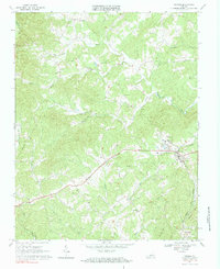
1967 Map of Ferrum
USGS Topo · Published 1984About this map
Ferrum serves as a central hub in the late 1960s, defined by the educational presence of Ferrum Jr College and the industrial transit of the Norfolk and Western railroad. The landscape is characterized by a dense network of country churches and family cemeteries, including St Peters Ch, Republican Ch, and Carter Cem, which are scattered among the ridges of Fivemile Mtn and Beech Mtn. These institutions reflect the social fabric of rural Franklin County, where small settlements like Prilliman and Graves are connected by winding roads and the drainage basins of the Pigg River and its South Prong. The presence of several community infrastructure sites, such as a Substation and Pumping Sta near the college, indicates a period of modernization while the surrounding topography remains dominated by creeks and runs like Butter Creek and Brown Hill Run.
Find a feature on this map
41 named features on this map. Tap any name to fly to it.
Don’t see what you’re looking for? This feature index may not catch every label — zoom into the map to look around manually.
Map Details
Editions of this 1967 Ferrum Map
Other maps of this area

1890 · Roanoke
USGS Topo · 1:125,000

1890 · Christiansburg
USGS Topo · 1:125,000

1891 · Roanoke
USGS Topo · 1:125,000

1925 · Rocky Mount
USGS Topo · 1:48,000

1927 · Rocky Mount
USGS Topo · 1:62,500

1944 · Rocky Mount
USGS Topo · 1:62,500

1947 · Roanoke
USGS Topo · 1:250,000

1950 · Elliston
USGS Topo · 1:62,500

1951 · Boones Mill
USGS Topo · 1:62,500

1953 · Winston-Salem
USGS Topo · 1:250,000