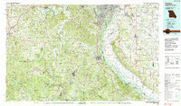
1985 Map of Festus
USGS Topo · Published 1987About this map
The Mississippi River corridor dominates this mid-1980s landscape, serving as the industrial and geographic divide between Missouri and Illinois. Centered on the twin cities of Festus and Crystal City, the map illustrates a region where river-based industry at Herculaneum meets the expanding suburban character of Arnold and Murphy. To the west, the terrain transitions into the heavily wooded Ozark foothills, preserved in large tracts such as the Mark Twain National Forest and Washington State Park.
Find a feature on this map
67 named features on this map. Tap any name to fly to it.
Don’t see what you’re looking for? This feature index may not catch every label — zoom into the map to look around manually.
Map Details
Editions of this 1985 Festus Map
This is the sole edition of this map. No revisions or reprints were ever made.
Other maps of this area

1888 · St. Louis
USGS Topo · 1:62,500

1890 · Hermann
USGS Topo · 1:125,000

1901 · De Soto
USGS Topo · 1:125,000

1903 · O'Fallon
USGS Topo · 1:125,000

1903 · Sullivan
USGS Topo · 1:125,000

1904 · Farmington
USGS Topo · 1:62,500

1905 · Bonneterre
USGS Topo · 1:62,500

1906 · Potosi
USGS Topo · 1:62,500

1906 · Farmington
USGS Topo · 1:62,500

1907 · Belleville
USGS Topo · 1:62,500