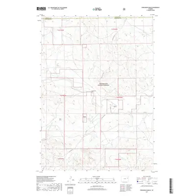
2017 Map of Fiddleback Ranch
USGS Topo · Published 2017About this map
Thunder Basin National Grassland dominates this high plains landscape near the convergence of Campbell, Converse, and Weston counties. The terrain is defined by a dense network of seasonal drainages and creek beds, including Antelope Cr and the Dry Fork Cheyenne River, which flow through various draws such as Sauerkraut Draw and Vest Draw. This area of eastern Wyoming remains sparsely settled, centered around established ranching operations like the Fiddleback Ranch. Transportation through this open range relies on a few primary arteries, notably Rochelle Hills Rd and Dull Center Rd. The survey provides a clear view of the complex land ownership patterns and administrative boundaries that characterize the Tbng region, showing how these federal lands intersect with local ranching infrastructure along the Cheyenne River.
Find a feature on this map
23 named features on this map. Tap any name to fly to it.
Don’t see what you’re looking for? This feature index may not catch every label — zoom into the map to look around manually.
Map Details
Editions of this 2017 Fiddleback Ranch Map
This is the sole edition of this map. No revisions or reprints were ever made.
Other maps of this area

1955 · Newcastle
USGS Topo · 1:250,000

1958 · Newcastle
USGS Topo · 1:250,000

1971 · Fiddleback Ranch
USGS Topo · 1:24,000

1971 · Coal Bank Draw
USGS Topo · 1:24,000

1971 · Esau Spring
USGS Topo · 1:24,000

1971 · Piney Canyon SW
USGS Topo · 1:24,000

1971 · Piney Canyon SE
USGS Topo · 1:24,000

1971 · Tin Can Lake
USGS Topo · 1:24,000

1974 · Reno Junction
USGS Topo · 1:100,000

1979 · Newcastle
USGS Topo · 1:100,000