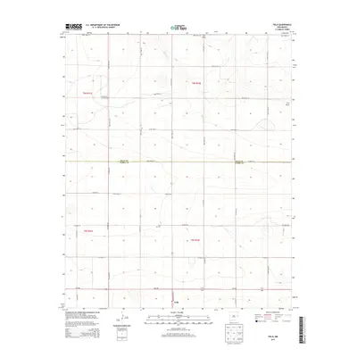
2013 Map of Field
USGS Topo · Published 2013About this map
Field serves as the primary junction point in this corner of New Mexico, where State Route 224 and NM-288 meet near the border of Curry and Quay counties. The landscape is defined by a series of low-lying drainage patterns, most notably the seasonal courses of Blanco Creek and Frio Draw. These features suggest a high-plains environment where water management and road networks are central to the small agricultural settlements of Dunn and Hall. Genealogists and local historians can locate the Field Cemetery, situated just north of the namesake community. The presence of Curtis Airport further north highlights the importance of aviation in these dispersed rural communities. The map provides a clear view of the section-line road system, including Quay Road 34 and County Road 28, which grid the territory for ranching and farming operations.
Find a feature on this map
25 named features on this map. Tap any name to fly to it.
Don’t see what you’re looking for? This feature index may not catch every label — zoom into the map to look around manually.
Map Details
Editions of this 2013 Field Map
This is the sole edition of this map. No revisions or reprints were ever made.
Other maps of this area

1954 · Clovis
USGS Topo · 1:250,000

1957 · Hammond Ranch
USGS Topo · 1:62,500

1958 · Clovis
USGS Topo · 1:250,000

1971 · Ragland
USGS Topo · 1:24,000

1971 · Grady SW
USGS Topo · 1:24,000

1971 · Forrest
USGS Topo · 1:24,000

1973 · Weber City
USGS Topo · 1:24,000

1973 · Field SE
USGS Topo · 1:24,000

1973 · Field SW
USGS Topo · 1:24,000
1973 · Field
USGS Topo · 1:24,000