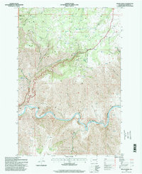
1995 Map of Fields Spring
USGS Topo · Published 1998About this map
Fields Spring State Park anchors this portion of Asotin County, situated amidst the dramatic elevation changes of the Blue Mountains region. The landscape is defined by the winding course of the Grande Ronde River, which carves deep into the terrain to create substantial landforms such as Shumaker Canyon and Deep Canyon. This 1990s survey, updated from earlier topographic work, illustrates a rugged area largely preserved as part of the Umatilla National Forest.
Find a feature on this map
26 named features on this map. Tap any name to fly to it.
Don’t see what you’re looking for? This feature index may not catch every label — zoom into the map to look around manually.
Map Details
Editions of this 1995 Fields Spring Map
This is the sole edition of this map. No revisions or reprints were ever made.
Other maps of this area

1943 · Saddle Butte
USGS Topo · 1:62,500

1944 · Anatone
USGS Topo · 1:62,500

1946 · Saddle Butte
USGS Topo · 1:62,500

1946 · Anatone
USGS Topo · 1:62,500

1955 · Pullman
USGS Topo · 1:250,000

1955 · Grangeville
USGS Topo · 1:250,000

1958 · Pullman
USGS Topo · 1:250,000

1959 · Grangeville
USGS Topo · 1:250,000
1967 · Paradise
USGS Topo · 1:24,000
1967 · Teepee Butte
USGS Topo · 1:24,000