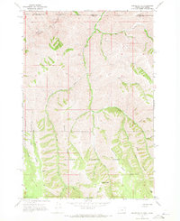
1967 Map of Teepee Butte
USGS Topo · Published 1971About this map
Teepee Ridge and Hunting Ridge define the high, dissected landscape of the Wallowa National Forest in this 1960s topographic study. The map captures a backcountry environment where movement is dictated by a network of primitive routes, including a Jeep Trail and various Pack Trails that descend into steep drainages like Joseph Creek and Cottonwood Creek. Human presence is represented by seasonal encampments and operational outposts, such as the Hunting Camp Cow Camp and the proximity of the Billy Meadows Guard Sta 6 Mi.. Located along the Washington and Oregon state line, the area is marked by numerous water sources vital for forest management and livestock, including Wildhorse Spring, Huffman Camp Spr, and the West Fork Creek. These features illustrate the traditional use of the high timber country for grazing and hunting during the mid-20th century.
Find a feature on this map
32 named features on this map. Tap any name to fly to it.
Don’t see what you’re looking for? This feature index may not catch every label — zoom into the map to look around manually.
Map Details
Editions of this 1967 Teepee Butte Map
This is the sole edition of this map. No revisions or reprints were ever made.
Other maps of this area

1944 · Anatone
USGS Topo · 1:62,500

1946 · Limekiln Rapids
USGS Topo · 1:62,500

1946 · Anatone
USGS Topo · 1:62,500

1955 · Pullman
USGS Topo · 1:250,000

1955 · Grangeville
USGS Topo · 1:250,000

1958 · Pullman
USGS Topo · 1:250,000

1959 · Grangeville
USGS Topo · 1:250,000

1963 · Jim Creek Butte
USGS Topo · 1:24,000

1963 · Poison Point
USGS Topo · 1:24,000
1967 · Table Mountain
USGS Topo · 1:24,000