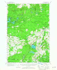
1956 Map of Fife Lake
USGS Topo · Published 1965About this map
The village of Fife Lake sits at the heart of this mid-century survey, surrounded by the dense woodlands of the Fife Lake State Forest and the Au Sable State Forest. The landscape is defined by its glacial hydrology, featuring dozens of named water bodies like Spider Lake, Guernsey Lake, and Rennie Lake. Transportation and industry center on the Pennsylvania railroad line, which links the settlements of Walton Junction and South Boardman through the river valleys.
Find a feature on this map
82 named features on this map. Tap any name to fly to it.
Don’t see what you’re looking for? This feature index may not catch every label — zoom into the map to look around manually.
Map Details
Editions of this 1956 Fife Lake Map
Other maps of this area

1954 · Traverse City
USGS Topo · 1:250,000

1956 · Mancelona
USGS Topo · 1:62,500

1956 · Kalkaska
USGS Topo · 1:62,500

1956 · Fife Lake
USGS Topo · 1:62,500

1956 · Kingsley
USGS Topo · 1:62,500

1956 · Mesick
USGS Topo · 1:62,500

1956 · Cadillac North
USGS Topo · 1:62,500

1956 · Lake City
USGS Topo · 1:62,500

1957 · Traverse City
USGS Topo · 1:62,500

1957 · Elk Rapids
USGS Topo · 1:62,500
Featured Places
- East Bay Township, MI
- Paradise Township, MI
- Acme Township, MI
- Whitewater Township, MI
- Fife Lake Township, MI