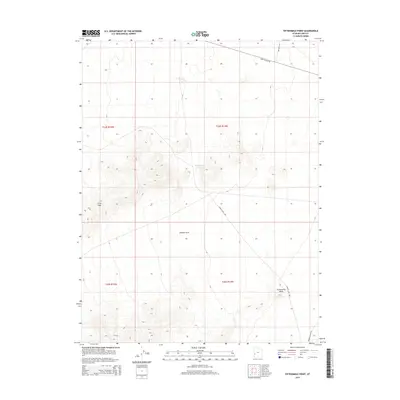
2014 Map of Fifteenmile Point
USGS Topo · Published 2014About this map
Lawson Cove Reservoir and the surrounding high desert terrain define this corner of Millard County. The landscape is marked by prominent natural features such as the Gray Hills and the distinct peak at Fifteenmile Point. Human movement through this arid region is traced by a network of established thoroughfares, including Crystal Peak Rd in the north and the winding Lawson Cove Way which cuts through the central basin. The map provides a detailed view of the Public Land Survey System divisions, including t24s r14w and t25s r14w, illustrating the geometric order imposed on the Great Basin's basin-and-range topography. This 2014 survey serves as a clear record of the area's hydrology and transit routes, highlighting the isolation and scale of Lawson Cove.
Find a feature on this map
12 named features on this map. Tap any name to fly to it.
Don’t see what you’re looking for? This feature index may not catch every label — zoom into the map to look around manually.
Map Details
Editions of this 2014 Fifteenmile Point Map
This is the sole edition of this map. No revisions or reprints were ever made.
Other maps of this area

1953 · Richfield
USGS Topo · 1:250,000

1958 · Richfield
USGS Topo · 1:250,000

1960 · Frisco Peak
USGS Topo · 1:62,500

1960 · Wah Wah Summit
USGS Topo · 1:62,500

1960 · Crystal Peak
USGS Topo · 1:62,500

1960 · The Barn
USGS Topo · 1:62,500

1980 · Wah Wah Mts. North
USGS Topo · 1:100,000
1989 · Frisco Peak
USGS Topo · 1:24,000
1989 · Wah Wah Cove
USGS Topo · 1:24,000
1989 · Wah Wah Summit
USGS Topo · 1:24,000