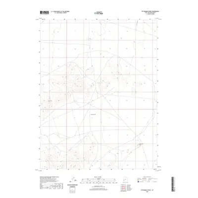
2020 Map of Fifteenmile Point
USGS Topo · Published 2020About this map
Lawson Cove Reservoir serves as a vital water collection point in this arid stretch of Millard County, where the desert floor meets the rising elevations of the Great Basin. The landscape is defined by the broad expanse of Lawson Cove, a natural basin flanked by the prominent Gray Hills to the west and the namesake Fifteenmile Point to the southeast. This 2020 survey illustrates the isolation of the region, where the only significant thoroughfare is the unpaved Tule Valley Rd cutting across the northeastern corner. The topography reveals a complex network of dry washes and alluvial fans that drain toward the cove, providing a detailed record of the drainage patterns essential for land management and geological study in this remote interior of Utah.
Find a feature on this map
5 named features on this map. Tap any name to fly to it.
Don’t see what you’re looking for? This feature index may not catch every label — zoom into the map to look around manually.
Map Details
Editions of this 2020 Fifteenmile Point Map
This is the sole edition of this map. No revisions or reprints were ever made.
Other maps of this area

1953 · Richfield
USGS Topo · 1:250,000

1958 · Richfield
USGS Topo · 1:250,000

1960 · Frisco Peak
USGS Topo · 1:62,500

1960 · Wah Wah Summit
USGS Topo · 1:62,500

1960 · Crystal Peak
USGS Topo · 1:62,500

1960 · The Barn
USGS Topo · 1:62,500

1980 · Wah Wah Mts. North
USGS Topo · 1:100,000
1989 · Frisco Peak
USGS Topo · 1:24,000
1989 · Wah Wah Cove
USGS Topo · 1:24,000
1989 · Wah Wah Summit
USGS Topo · 1:24,000