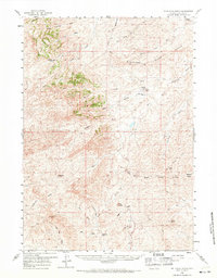
1959 Map of Fifty-Five Ranch
USGS Topo · Published 1971About this map
Isolated cattle ranches and high plains drainage systems define this mid-century look at the Wyoming landscape. The Cheyenne River serves as the primary hydrological artery, fed by a complex network of seasonal flows including the North Fork and Middle Fork. Named family holdings such as the Old Bryan Ranch and the Fifty-five Ranch indicate the sparse, large-acreage settlement pattern of the era. Evidence of early rural infrastructure and industry is visible near the Badger Sch and the Badger Mine. The terrain is marked by distinctive elevations like Blue Hill and Blizzard Heights, while the Eskew No 2 Res provides a rare point of managed water storage in this arid environment. Significant survey labels such as Road Divide and the Divide highlight the natural watershed boundaries separating the Cheyenne from the Bear Creek systems.
Find a feature on this map
41 named features on this map. Tap any name to fly to it.
Don’t see what you’re looking for? This feature index may not catch every label — zoom into the map to look around manually.
Map Details
Editions of this 1959 Fifty-Five Ranch Map
2 editions found

Other maps of this area

1949 · Campbell Hill
USGS Topo · 1:24,000

1949 · Leuenberger Ranch
USGS Topo · 1:24,000

1949 · Glenrock NW
USGS Topo · 1:24,000

1949 · Hylton Ranch
USGS Topo · 1:24,000

1950 · Campbell Hill
USGS Topo · 1:24,000

1950 · Leuenberger Ranch
USGS Topo · 1:24,000

1950 · Glenrock NW
USGS Topo · 1:24,000
1950 · Hylton Ranch
USGS Topo · 1:24,000

1954 · Torrington
USGS Topo · 1:250,000

1955 · Newcastle
USGS Topo · 1:250,000